New to CCDL – Maps and Mapping at the Claremont Colleges

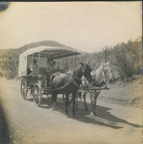
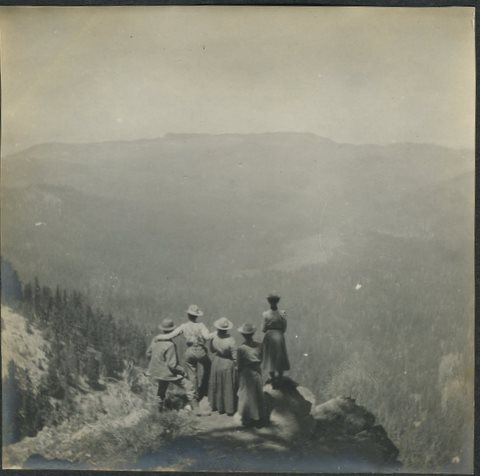
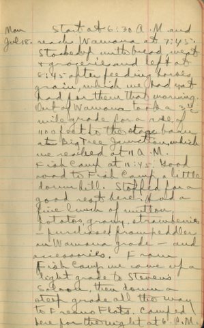
The maps here are a few examples from the Maps and Mapping at the Claremont Colleges collection found in the the Claremont Colleges Digital Library (CCDL). Thanks to funds donated by William Brownell, father of a Pomona College student, Special Collections was able to digitize 150 of our maps for easy online access.


Many items in our map collections spell out the settlement of North America in the languages of European settlers. Whether in English, French, or Spanish, map holdings depict the exploration and administration of the American West and Pacific coast from the years 1542-1949. Just as books are written with the author’s intent, many of these maps depict the land according to the mapmaker’s agenda.


Some cartographers would stretch and crop the land to fit their own politics. Spanish colonial administrators promoted the idea of California as a chain of islands called the Carolinas. This concept of the West Coast spread and was recreated by non-Spanish cartographers, in the case of the two maps below.

A_new_map_of_the_world_according_to_Wrights_alias_Mercators_projection_c (2).jpg
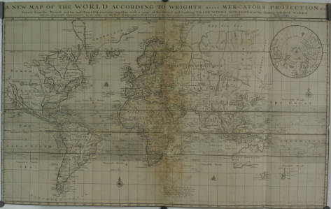
A New Map of the World According to Wright’s alias Mercator’s projection &c, an English map created in 1700 by Herman Moll. Note the California island.


Front (2).jpg
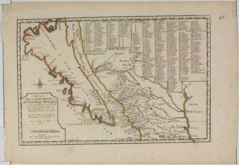
Californie et Du Noveau Mexique, a French reproduction of a Spanish map drawn for the Viceroy of New Spain, 1700


Even though maps from the late 1500s, like the one below, correctly show California as a southern peninsula and northern mainland, Spanish mapmakers spread the image of an island among other nations to avoid competition with the British. Not wanting to argue about the right to acquire new portions of the mainland, Spaniards simply claimed it was an archipelago. Colonial viceroys and mapmakers circulated this idea until King Phillip forced them to stop in the middle of the 18th Century.


Front (3).jpg
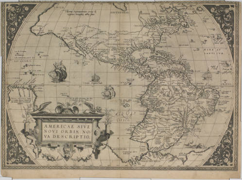
Americae sive novi orbis, nova description, by Abraham Ortelius, 1570. Note the peninsular California. Donated as part of the Henry R. Wagner Collection.

Other maps in this collection imply competition by later colonial powers. The 1811 American map below outlines towns, military outposts, and natural resources of Spanish Mexican states bordering the Louisiana Purchase. The detail of said locations likely reflects the cartographer’s interest in acquiring those lands. Given the Texan revolt and the Mexican war of the late 1830s and early 1840s, this may have become a common political opinion.


Spanish_dominions_in_North_America_northern_part (1).jpg
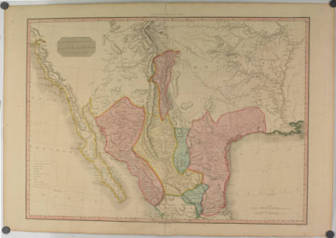
Spanish dominions in North America, northern part, by L. Hebert and John Pinkerton, 1811

Natural resources and landforms were key to settlers, as in the below map of 1850s California. The map outlines topography, cities, and mineral districts, all of which would have been important for settling in a nice place or striking it rich during the gold rush era. This map was composed from survey data by John Trask, California’s first state geologist. California was officially part of the United States at the time, and the huge amount of survey data on the map shows the Americans’ intention to stay for good.


Topographical_map_of_the_mineral_districts_of_California_Being_the_first_map_ever_published_from_actual_survey.jpg
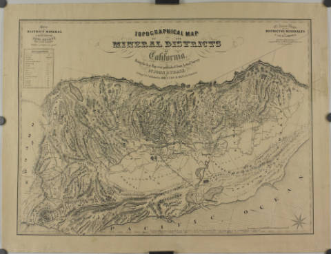
Topographical map of the mineral districts of California: Being the first map every published from actual survey, by John B. Trask, 1853


Just as this entry offers a glimpse of what is held in the Maps and Mapping at the Claremont Colleges collection, the digital collection only begins to reflect the collection of maps held in Special Collections. This digital collection will continue to grow, with the goal of increasing access to the resources available through the Claremont Colleges Library.

This entry was written by Special Collections Student Assistant Dalton Martin (Pomona College ’18).

New to CCDL – West-ography

The West-ography, re-imaging the West Collection is made up of different photographic approaches to documenting the rich and changing contexts that have characterized the American West. Early photography of the West focused on capturing the unique landscapes that the West had to offer and on creating portraits of Native Americans. As time went on, photographers began to make portraits of pioneers and started to document many aspects of life in the West like Western fiestas and pageantry.

In the West-ography Collection, visitors can go through Edward S. Curtis’ The North American Indian: being a series of volumes picturing and describing the Indians on the United States, and Alaska (numbered plate portfolios and boxes 1 and 4). This body of work began in 1906 when Curtis was commissioned by JP Morgan to make photos of the American Indians. Morgan paid Curtis $75,000 (around $2,000,000 in today’s money) to complete the project which would take him around 20 years to do.

Curtis’ goal in the project was to not only make photos of the American Indians he encountered, but also to document their fading way of life. To that end, he brought along a team of scholars including anthropologists and journalists. Throughout this pursuit, Curtis took over 40,000 photographs of Native Americans from over 80 tribes and carefully depicted their way of life through written records.


westography.jpg
All images are from The North American Indian: being a series of volumes picturing and describing the Indians of the United States, and Alaska, by Edward S. Curtis, published by The University Press (Cambridge, Mass.), beginning in 1907 and culminating in 1930. The full set is held in Special Collections at the Claremont Colleges Library.

Currently, the collection includes select Edward S. Curtis photogravures from his The North American Indian: being a series of volumes picturing and describing the Indians of the United States, and Alaska numbered plate portfolios and boxes 1 and 4 from the Charles Lummis photograph collection which cover the American southwest and California.

Future plans include adding photographs from the Marion Parks Papers and a variety of other materials from Special Collections, Claremont Colleges Library which contain Western imagery.

Parks’ photographs include “La Fiesta de Los Angeles”- which was an annual “celebration of Southern California and the Southwest” in the 1890s and other historical pageants/events in Los Angeles. Though the initial focus is on photographs, it is hoped other “imaging” media such as video files, audio files, and ephemera will also be added to this collection. This collection is a “work in progress” so please check back regularly.

This entry was written by Special Collections Student Assistant, Tristan Marsh (Pomona College ’18).

In the Limelight: California Citrus

Citrus_in_the_Sky3-sm.jpg
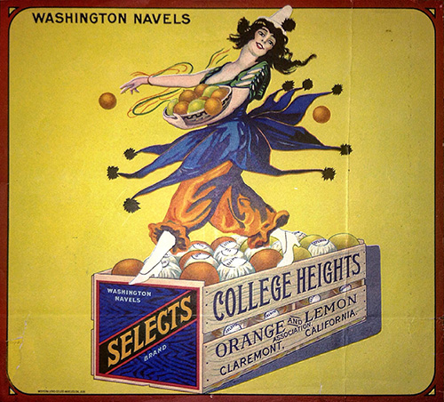
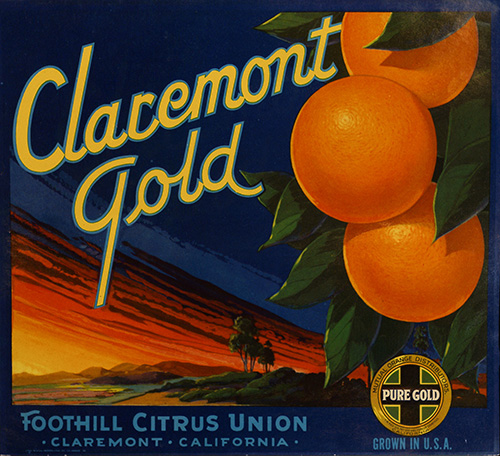
Fred Allen, one of the most popular comedians from the Golden Age of American radio, once quipped, “California is a fine place to live – if you happen to be an orange”. As it turns out, Claremont, California is an especially fine place to live – if you happen to be an orange crate label!

This summer, Special Collections presents In the Limelight: California Citrus, an exhibition centered on the history of the citrus industry in the Claremont area, curated by Grace Rodriguez (CMC 2015). Our inspiration stems from the recently-acquired Oglesby Citrus Label collection, which consists of over 80 labels as well as several books related to label collecting and history. The most aesthetically dazzling and unique are on display, and originate from growers and packinghouses within the Claremont and Pomona area. The labels are supplemented with various other texts, photographs, and ephemera from our extensive collections including, but not limited to, paper citrus wrappers from Valentine Peyton (a prominent orange grower in La Verne), aerial photographs of Claremont covered in orange groves (circa 1939), and various issues of the California Citrograph, the industry’s official trade publication from 1915 to 1969.

IMG_0913-sm.jpg
In the Limelight stages citrus as the protagonist in Southern California’s rapid development during the early 20th century. Our exhibition also accentuates the orange’s role in selling the “California Dream” to people from across the country and even around the world…. Citrus crate labels were not just selling fruit! They are a juicy resource for anyone interested in advertising and marketing history, artistic styles of the period, representation of California and its people (native or non-native), and so much more.

Claremont_Gold-sm.jpg
The exhibit is located outside of the Special Collections Reading Room, in the 2nd floor Honnold foyer. It may been viewed at any time during the Library’s summer operating hours (Monday-Friday, 8:30am-7pm, and Saturday, noon-7pm). If you have any questions or want to see more of our collections, the Reading Room is open to the public during the summer on Monday through Friday, 1-5pm. You can also reach us by email (spcoll@cuc.claremont.edu) or phone (909-607-3977).

7th Annual Los Angeles Archives Bazaar

ab7_300.jpg
Students, teachers, historians, and local history enthusiasts will find a treasure trove of L.A. history at the 7th Annual Los Angeles Archives Bazaar. Presented by L.A. as Subject, a research collective hosted by the USC Libraries, the Bazaar offers numerous resources for exploring the rich histories of L.A.’s diverse neighborhoods and communities and virtually any subject related to the Los Angeles region.
Held at the Doheny Memorial Library on the USC campus, the Bazaar will feature exhibits over 70 local historical collections, museums, libraries and archives. Attendees can browse collections, schedule research visits, and consult with experts. Throughout the day, educational programming will cover a range of topics.
Special Collections, Honnold/Mudd Library and the Ella Strong Denison Library will share an exhibitor table – be sure to stop by and see us!
Admission is FREE!
Date: Saturday, October 27, 2012
Time: 9:00 a.m. to 5:00 p.m.
Doheny Memorial Library
USC University Park Campus
For more information visit https://laassubject.org/archives-bazaar

“Touring Yosemite” Exhibit

Lyman.jpg

Now through December 22, come “tour” Yosemite through books, photographs, drawings, ephemera and other, mostly 19th century, primary source materials.
See how visitors traveled to Yosemite. See where they stayed and what they did and saw. See how they reflected upon their experiences after leaving this wondrous place!

CampAhwahnee.jpg

You can visit the exhibit anytime during Honnold/Mudd Library hours. Exhibit space is located 2nd floor, Honnold side, just inside the North entrance and just outside Special Collections. Exhibit was co-curated by Char Miller, W. M. Keck Professor of Environmental Analysis, Pomona College and Lisa Crane, Western Americana Librarian, Special Collections, Honnold/Mudd Library.

BancroftsTG.jpg

Many items are on loan for this exhibit. However, some items from Special Collections, Honnold/Muud Library are also included; such as a 1904 diary and photo album from Pomona College, Class of 1900 alum Robert P. and Alice B. Jennings documenting their trip from Los Angeles to Yosemite via wagon and stereoview photographs from the Martin Mason Hazeltine collection.

There will be two related programs:

On Saturday, October 13th there will be a reception, talk and gallery tour by Denny Kruska, Los Angeles author and bibliographer, who loaned many of the materials on display. More details to follow.

On Wednesday, October 31st, Char Miller will give a Claremont Discourse Lecture on “Public Lands, Public Debates: A Century of Controversy”, his latest publication.

So save the dates! More information coming!

Hazeltine stereoscopic views of Yosemite

hazeltine.jpg
The Martin Mason Hazeltine stereoview collection was recently purchased by Special Collections, Honnold/Mudd Library and its finding aid listing titles of all items can be viewed at the Online Archive of California.
Fifty-three stereoviews, plus one duplicate, of Yosemite Valley and the California Big Trees scenic views. All marked with the studio imprint of John P. Soule. This “California” series of photographs was produced by the photographer Martin Mason Hazeltine (1827-1903), though no credit is given him on these images. Hazeltine, a Vermont native, moved to California and established a studio in Mendocino in the late 1860s. Among his works, he produced many western images, including this Yosemite series, and one on the Yellowstone. His photos were published by other firms, including J. P. Soule, and Lawrence & Houseworth.

The 6th-Annual Los Angeles Archives Bazaar

ab11_fullgraphic.jpg
Los Angeles history comes alive at this annual event which celebrates the diversity of Southern California’s history. For scholarly researchers, journalists, history buffs, and those simply interested in exploring the stories of Los Angeles, discovery awaits everyone at the Archives Bazaar. Honnold/Mudd Library Special Collections and Denison Library will be exhibiting.


FMI: https://laassubject.org/

Thank you, KCET blog!

Two recent entries in the KCET blog featuring Special Collections!
Course Correction: L.A.’s Water Future Lies in Its Past” written by Pomona College professor Char Miller, Director of the Environmental Analysis Program, featuring the Fred Eaton photo album in the Water Resources Collection
eaton-and-others.jpg
Fred Eaton is in the third man from the right
and
What Rodeo Drive Looked Like in 1925 & More Hidden Treasures of SoCal’s Archives” featuring the Dr. Walter Lindley Scrapbooks
california-hospital-nurses-thumb-250x250-12640.jpg
New graduates from the California Hospital nursing program, 1905, founded by Dr. Lindley

Travel Bible

We have many Bibles in our rare book collections, several of them “landmark” editions such as the Bishop’s Bible (1568) and the first King James (1611) to name two. Yet among my favorites is an American travel Bible (1856), unremarkable with its brown cloth binding.
travel bible001-1
Written inside the front cover and on the first flyleaf, however, are remarkable notes left by two previous owners. The first recounts the travels of G.E.O. throughout the American west during the mid 19th century.
travel bible002.jpg
On the flyleaf is a note in pencil, perhaps written by the former owner’s son, of his own travels through Europe and metropolitan U.S., taking the travel Bible with him.
travel bible002-1
Call number Honnold Special Collections BS 185 1856 N43

1904 Trip to Yosemite in a Covered Wagon

In 1904 an intrepid young married couple, Robert and Alice Jennings, drove a covered wagon from the city of Los Angeles to Yosemite. They had taken the trip at least one time before, and on that earlier Yosemite trip, they rode by train to Fresno then traveled by stagecoach to Yosemite.
Robert and Alice Jennings both graduated from Pomona College in 1900 and were married soon after. Their grandson, Robert A. Jennings, and his family recently gave to Pomona College two accounts of their 1904 Yosemite trip: a diary and a photo album. While the photo album records views of the trek to Yosemite that no longer exist–a dirt track created by wagons through Tejon Pass; the gargantuan grapevine that gave its name to that area, the “Grapevine”; unpopulated canyons–the diary tells of the extremes of the landscape and of the weather but also of the fun that the couple had on their journey.
Alice Jennings in the covered wagon, drawn by “Samanthy” and “Jim”:
jennings001
At Wawona Point:
jennings002
Monday July 18th, diary entry for the Wawona visit:
jennings003
The Jennings’ photo album and diary of their trip to Yosemite in 1904 can be viewed in person at Special Collections, Honnold/Mudd Library.